
Supervisor: Florian Kleber, Simon Brenner
Start: as soon as possible
Problem Statement
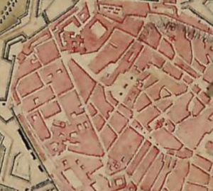
Historical maps contain a lot of information like land boundarys or outlines of buildings. To show the development of citys and different regions it is necessary to extract this information from historical maps. Within this work the main goal will be detect the outlines of buildings. The dataset together with the Ground Truth will be provided. An example image is shown below.
Goal
The goal of the practical course (Informatik Praktikum) / Bachelor thesis is to train a State of the Art Neural Network to segment the outline of the domiciles/houses and compare the chosen approach to other state of the art methods. The dataset will be provided (including GT).
Workflow
Literature research
Implementation in Python or C++
Evaluation of the system
Written report or bachelor thesis (in English) and final presentation
Requirements
Python or C++
Basic knowledge in Computer Vision
Basic knowledge in Deep Learning (Tensorflow, PyTorch) and Machine Learning